Tilted planes
Posted: Sat Mar 05, 2005 3:05 am
Hi,
When I finish writing this post, I will upload:
http://www.ptsim.com/downloads/sbyyy.zip
a pre-version of SBuilder 2.05 that uses a new polygon format to support tilted planes. I made routines to convert old projects to version 2.05 but please be careful (now SB writes a backup file just in case). Before Sbuilder 2.05, LINES were sets of XYZ points defined by:
- longitude
- latitude
- width
and POLYS were sets of XY points defined by:
- longitude
- latitude
Now POLYS are sets of XYZ points defined by:
- longitude
- latitude
- altitude
Important Notes:
a) point altitudes in polygons are ignored in all cases except in polygons of type LWM.
b) LWM BGLs are now generated with "Poly3()" style commands. Therefore they will not work anymore in FS2002.
c) when you generate a LWM mask you need to press "Change" in the altitude box in order to set the altitude. "OK" is not sufficient. The idea is to make the working with "altitudes in polygons" very similar to the working with "widths in lines".
Here is a illustrated example to create a tilted plane. You can use this for tilted runways or for LWM rivers that approach the sea (altitude is 0 when the river reaches the sea but not 0 when the river is far from reaching the sea ocean).
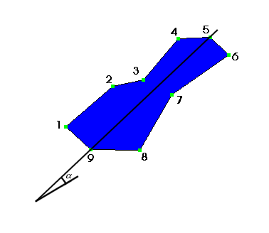
In the example I have a polygon with 9 points. I want Point 9 to have an altitude of 20 meters and point 5 to have an altitude of 60 meters. The line that contains points 9 and 5 makes an angle of alpha with the horizontal plane. I want all the remaining points of the polygon to belong to the tilted plane that passes through 9 and 5 and that makes an angle of alpha with the horizontal plane. Here is what I have to do:
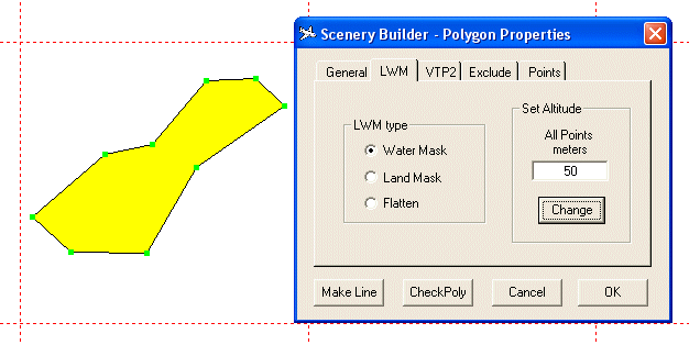
I start by drawing a polygon in the normal way (yellow). Then I enter the properties page and define the type of the polygon to be LWM WATER. I enter an altitude of 50 meters which will be applied to all points as soon as I press "Change". I used the value of 50 as it is a value between the extreme values of 20 and 60 that I want to define for the 2 important points - point 9 and point 5!. Then:
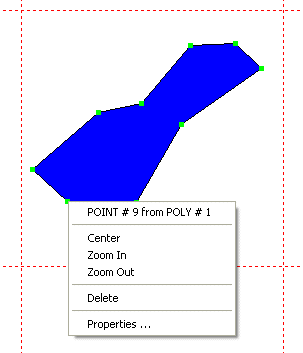
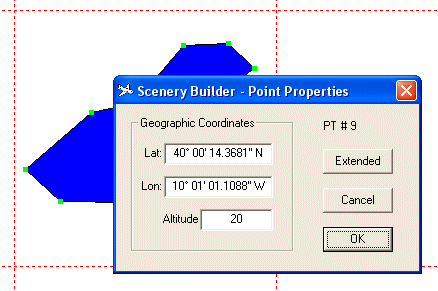
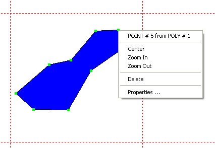
I enter the properties of point 9 and I declare its altitude to be 20 meters as in this picture:
And then I do the same for point 5:
I skip the picture where I declare the altitude of Point 5 to be 60 meters and I show the what I get if I reenter the properties of the polygon. I go for the "Points" window which looks very similar to the one you get when you are setting widths in VTP lines. The main difference is that you set altitudes instead of widths:
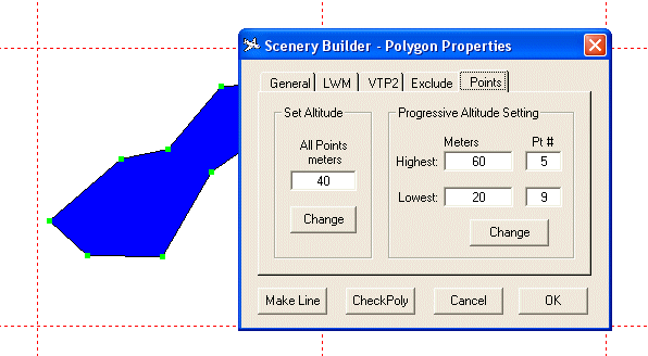
The window shows the highest and the lowest point which is in accordance to the previous settings. Now if I press "Change" in the Progressive window, points 1 2 3 4 6 7 and 8 will get the altitude that places them in the target tilted plane.
That is all. Do not press "Change" on the left as it would make all points at 40 meters! Just press OK and compile to see the result.
******** Remeshing? will it work? ********
You can set altitudes of individual points and force the mesh to your altitudes. I did not test this and will be glad to hear of any trials.
I also wish to receive feedback on this feature. I plan to use these tilted planes in conjunction with textured polygons to make photo scenery that "brakes" the 4.8 meter barrier.
Regards, Luis
When I finish writing this post, I will upload:
http://www.ptsim.com/downloads/sbyyy.zip
a pre-version of SBuilder 2.05 that uses a new polygon format to support tilted planes. I made routines to convert old projects to version 2.05 but please be careful (now SB writes a backup file just in case). Before Sbuilder 2.05, LINES were sets of XYZ points defined by:
- longitude
- latitude
- width
and POLYS were sets of XY points defined by:
- longitude
- latitude
Now POLYS are sets of XYZ points defined by:
- longitude
- latitude
- altitude
Important Notes:
a) point altitudes in polygons are ignored in all cases except in polygons of type LWM.
b) LWM BGLs are now generated with "Poly3()" style commands. Therefore they will not work anymore in FS2002.
c) when you generate a LWM mask you need to press "Change" in the altitude box in order to set the altitude. "OK" is not sufficient. The idea is to make the working with "altitudes in polygons" very similar to the working with "widths in lines".
Here is a illustrated example to create a tilted plane. You can use this for tilted runways or for LWM rivers that approach the sea (altitude is 0 when the river reaches the sea but not 0 when the river is far from reaching the sea ocean).
In the example I have a polygon with 9 points. I want Point 9 to have an altitude of 20 meters and point 5 to have an altitude of 60 meters. The line that contains points 9 and 5 makes an angle of alpha with the horizontal plane. I want all the remaining points of the polygon to belong to the tilted plane that passes through 9 and 5 and that makes an angle of alpha with the horizontal plane. Here is what I have to do:
I start by drawing a polygon in the normal way (yellow). Then I enter the properties page and define the type of the polygon to be LWM WATER. I enter an altitude of 50 meters which will be applied to all points as soon as I press "Change". I used the value of 50 as it is a value between the extreme values of 20 and 60 that I want to define for the 2 important points - point 9 and point 5!. Then:
I enter the properties of point 9 and I declare its altitude to be 20 meters as in this picture:
And then I do the same for point 5:
I skip the picture where I declare the altitude of Point 5 to be 60 meters and I show the what I get if I reenter the properties of the polygon. I go for the "Points" window which looks very similar to the one you get when you are setting widths in VTP lines. The main difference is that you set altitudes instead of widths:
The window shows the highest and the lowest point which is in accordance to the previous settings. Now if I press "Change" in the Progressive window, points 1 2 3 4 6 7 and 8 will get the altitude that places them in the target tilted plane.
That is all. Do not press "Change" on the left as it would make all points at 40 meters! Just press OK and compile to see the result.
******** Remeshing? will it work? ********
You can set altitudes of individual points and force the mesh to your altitudes. I did not test this and will be glad to hear of any trials.
I also wish to receive feedback on this feature. I plan to use these tilted planes in conjunction with textured polygons to make photo scenery that "brakes" the 4.8 meter barrier.
Regards, Luis