First Time Out - Adding Objects and Stuff
Posted: Sat Jan 22, 2011 8:16 pm
Hi all,
Thanks for such a God send. My first project was born in pangs of labor but I have a handle on the photo scenery now. But I have some questions. Here are some screenies, I am trying to create visual cues to simulate real world course rules for use in a virtual UPT program.
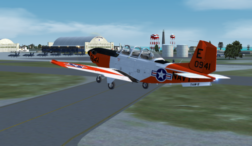
Departing Jim Dhaenens' KNPA:
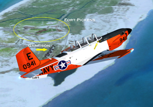
Flying East past Fort Pickens:
Langdon Battery:

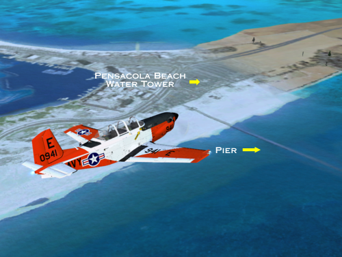
Pensacola Beach:
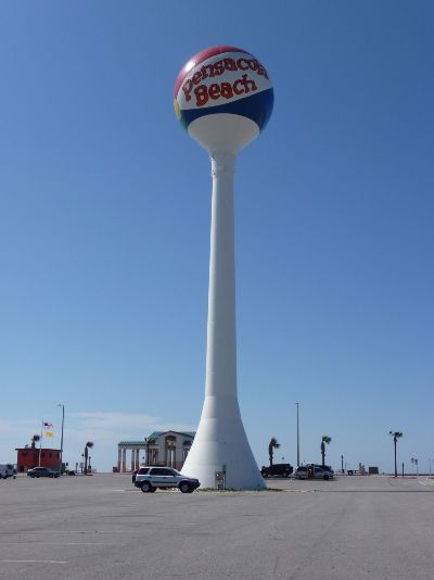
Land Mark I'd Like to Have...Water Tower:
My first questions are about adding objects from the library:
When I add default objects via SBuilder, I cannot seem to get them to position correctly when displayed in FSX. When I see the thumbnail I see the green reticule and red arrow, how does this relate to the object? I.E. Does the red arrow indicate the direction that it faces? If so does the bounding box have any reference to correlate? Does expanding the box change the dimensions of the object?
Making MDLs for FSX:
I cannot find a water tower nearly close enough to act in place of the Pensacola Beach Tower. I would also like to model Langdon Battery and Fort Pickens. Is there a suggested software with a low learning curve that an old brain can learn?
File Size:
When I am finished I am making this available to those who want to fly the course. The image alone is 248 MB! I've downloaded bigger files but is this normal for the Hi-Res (Zoom 17) stuff? Any compression techniques that don't rob quality?
Elevation:
Maybe I a missing something, but I can't find it. Is there a tool within SBuilder to alter portions of the elevation? I.E. Langdon battery sits half buried in a dune faced with scrub. It is about 10' higher than the surrounding terrain.
Thanks again for this wonderful piece of equipment. Any advice would be greatly appreciated.
BTW, not bad for a first time, huh?
Kyle
Added in Edit: Sorry, the terrain in question is Santa Rosa Island from about Pensacola Beach to Fort Pickens.
Thanks for such a God send. My first project was born in pangs of labor but I have a handle on the photo scenery now. But I have some questions. Here are some screenies, I am trying to create visual cues to simulate real world course rules for use in a virtual UPT program.
Departing Jim Dhaenens' KNPA:
Flying East past Fort Pickens:
Langdon Battery:
Pensacola Beach:
Land Mark I'd Like to Have...Water Tower:
My first questions are about adding objects from the library:
When I add default objects via SBuilder, I cannot seem to get them to position correctly when displayed in FSX. When I see the thumbnail I see the green reticule and red arrow, how does this relate to the object? I.E. Does the red arrow indicate the direction that it faces? If so does the bounding box have any reference to correlate? Does expanding the box change the dimensions of the object?
Making MDLs for FSX:
I cannot find a water tower nearly close enough to act in place of the Pensacola Beach Tower. I would also like to model Langdon Battery and Fort Pickens. Is there a suggested software with a low learning curve that an old brain can learn?
File Size:
When I am finished I am making this available to those who want to fly the course. The image alone is 248 MB! I've downloaded bigger files but is this normal for the Hi-Res (Zoom 17) stuff? Any compression techniques that don't rob quality?
Elevation:
Maybe I a missing something, but I can't find it. Is there a tool within SBuilder to alter portions of the elevation? I.E. Langdon battery sits half buried in a dune faced with scrub. It is about 10' higher than the surrounding terrain.
Thanks again for this wonderful piece of equipment. Any advice would be greatly appreciated.
BTW, not bad for a first time, huh?
Kyle
Added in Edit: Sorry, the terrain in question is Santa Rosa Island from about Pensacola Beach to Fort Pickens.